Imagine backing your boat off a private lift, idling through calm canals, and pointing the bow toward Pine Island Sound for a smooth run to the Gulf. If that is your vision, Island Estates in St. James City on Pine Island deserves a close look. Buying here is about more than a pretty view. It is about matching your boat and lifestyle to the exact waterway, bridge clearances, and dock rules at a specific lot. In this guide, you will learn how to vet routes, docks, depths, permits, and timelines so you can buy with confidence. Let’s dive in.
Island Estates on Pine Island: Know your water
First, confirm you are looking at Island Estates in St. James City, Lee County. The name appears in multiple Florida markets, so verify the subdivision in listing details or parcel records. You can see examples confirming the St. James City usage in local listings for Island Estates on Pine Island. This listing reference shows the right geography.
Next, map how you will reach the Gulf. From Pine Island waters, you run to Matlacha Pass and Pine Island Sound, then use nearby inlets around Sanibel and Captiva. Local skippers and charter captains highlight these routes for fishing and cruising in the area, which helps anchor your on-water expectations. For context on Pine Island boating waters, review this local Pine Island overview.
A quick note to avoid confusion: Clearwater Pass is in Pinellas County. It is not the Gulf exit for Lee County waterways. Your Island Estates routes use Matlacha Pass and Pine Island Sound.
Map your route to the Gulf
Route planning is the key to loving your purchase. Before you write an offer, do the following:
- Chart the path from the property to the Gulf. Note fixed bridges, any drawbridges, and typical no-wake zones.
- Run time estimates at your normal cruise speed and a conservative tide. Track manatee speed zones and seasonal restrictions that can slow transits.
- List the closest marinas, fuel docks, and pump-out facilities on your way out and back.
Bridge operations can define your boat choice and schedule. Drawbridge rules for routes like Matlacha Pass are published in official navigation guides. Check the U.S. Coast Pilot or USCG bridge regulations for exact opening schedules before you commit to a property. You can start with the U.S. Coast Pilot reference and confirm locally.
If you want to validate parcel-level details during your research, Lee County’s parcel and land-records layers can help you see attributes like BOATDOCK or SEAWALL where recorded. Explore the county’s parcel and land records layer for a starting point.
Match the lot to your boat
Not every waterfront lot is equal for navigation. Your vessel’s length, beam, height, and draft need to match the canal type, basin width, and route constraints.
Canal width, depth, and turning room
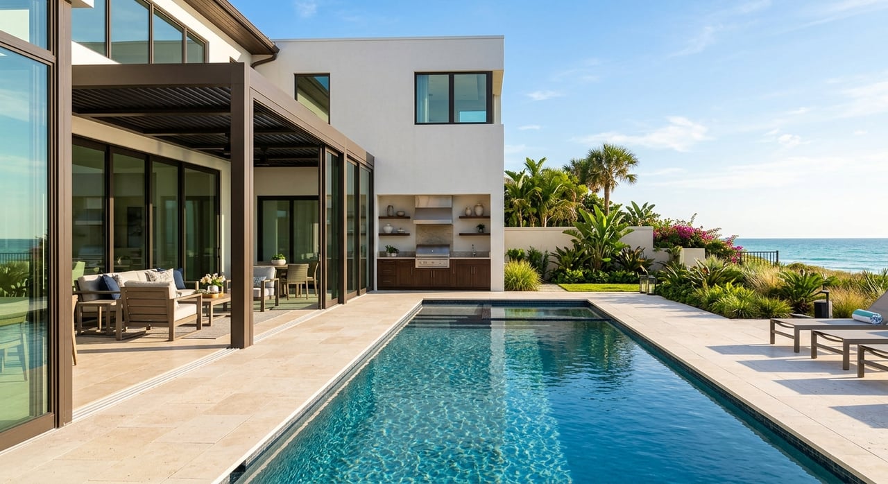
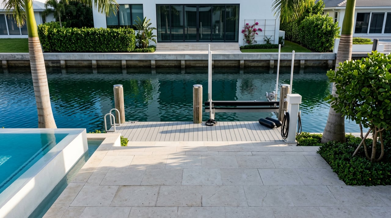
- Canal type: Identify whether the lot fronts a wide basin, a narrow finger canal, or open estuary. Natural mangrove edges often have shallower turns. Man-made canals vary in width, depth, and whether they have seawalls and private docks. Field soundings are the only way to confirm depths.
- Depth at MLW: Ask for a recent sounding survey in front of the lot and along the approach channel. You need depth at Mean Low Water at the dock face and throughout your turning and exit path.
- Turning radius: Confirm you can safely maneuver. Look for bulkheads, docks across the canal, or other fixed obstacles that may limit swing.
For recorded site attributes like BOATDOCK or SEAWALL, check county records as a cross-reference. Start with the Lee County land records layer to see what is on file, then verify physically.
Bridge clearances and your vessel height
Vertical clearance sets a hard cap on what you can run from your dock without waiting on openings. Use your vessel’s highest fixed point and add a safety margin before deciding a route is viable. Obtain fixed-clearance data and any drawbridge schedules from official navigation publications, then confirm with local marinas. The U.S. Coast Pilot reference is a reliable place to begin.
Boat lifts and capacity
If a property includes a lift, confirm the rated capacity, certify date, and whether the installation has engineering approval and permits. Residential lifts range from small skiff ratings to heavy-lift systems for larger vessels. The manufacturer’s specifications and stamped engineering plans control safety, insurance, and practical use. Plan upgrades only after you know what local codes and state or federal rules allow.
Docks, seawalls, and what permits allow
Waterfront improvements are governed by local code as well as state and federal review. A clear paper trail is essential.
Common layouts and local projection limits
Typical residential configurations include platform docks for small craft, T-docks or finger piers for a single berth, multi-piling setups with lifts, and in some areas floating segments. Many municipalities limit how far you can project into the waterway and how much area you can cover. As an example of how such limits work, see the City of Cape Coral’s marine improvements code. Your lot may be under different rules, so always check the specific jurisdiction for St. James City or unincorporated Lee County.
Seawalls: condition and documentation
Seawalls support both the shoreline and the dock system. Ask for age, engineering reports, and any replacement permits. County parcel and permit history often show whether a recent seawall project was recorded. Begin your review with Lee County parcel and land records and then confirm details during inspections.
State and federal overlay: FDEP and USACE
Any structure waterward of the mean high-water line may require state authorization and could trigger federal review, especially if dredge or fill are involved. Florida Environmental Resource Permits can include conditions such as seagrass avoidance or reduced shading, and larger or multi-slip projects often use submerged-lands leases. For a primer on how these layers interact, read this Florida dock permitting summary.
Manatees, seagrass, and timing windows
Lee County uses a State-approved Manatee Protection Plan to guide siting and review of boat facilities. Projects in sensitive habitat may have design conditions, signage requirements, or seasonal timing limits. You can review the county plan and resources within the Lee County Manatee Protection Plan hub.
Contractor vetting and timeline
Selecting the right marine contractor is as important as picking the right lot. Complete these checks before you sign:
- Verify the contractor’s license status and specialty with the Florida DBPR. The state publishes license verification and important consumer resources. Start with the DBPR resource page.
- Request proof of insurance, local references, and examples of permitted projects similar to your scope. Require in writing that the contractor will obtain all permits before mobilizing.
- Keep your documentation organized. Ask for as-built drawings, engineered plans, and all authorizations when the work is complete.
As for timing, simple residential slips or lifts that qualify for streamlined paths can resolve in weeks to a few months if applications are complete. Projects that need Environmental Resource Permits, submerged-lands leases, dredging, or multi-agency coordination commonly take many months and can extend past a year, especially if public notice is required. See the Florida dock permitting summary for expectations and why Requests for Additional Information can add time.
Buyer showing checklist
Use this quick list to align your boating habits with the right Island Estates property in St. James City:
- Confirm the exact subdivision and parcel ID. If a listing is ambiguous, verify that it is Island Estates on Pine Island. Check county attributes like BOATDOCK and SEAWALL in the Lee County land records layer. Also see a local Island Estates listing example for context.
- Route and time to Gulf: if possible, boat the route or consult local captains to estimate run times in different tides. Note bridges, restricted channels, and manatee zones. For regional context, scan this Pine Island water overview.
- Depth and turning: obtain a recent sounding at the dock face and in the approach channel. Compare MLW depth to your boat’s minimum under power.
- Dock footprint and legal status: request as-built drawings and permits. Confirm the permitted footprint matches the physical dock.
- Seawall condition: ask for inspection reports or permit history that show age and recent work. Start your records search in the county land records.
- Lift and utilities: verify lift rating, age, wiring, and water service. If you plan to upgrade, check local code limits and state or federal requirements first. As an example of projection and canopy restrictions, see Cape Coral’s code.
- Neighbors and navigation: observe how adjacent docks use the waterway. Multi-slip activity near a narrow canal can affect maneuvering and future reviews.
- Insurance and flood exposure: review FEMA flood maps, base flood elevation, and likely insurance requirements for wind, flood, and your vessel. County parcel layers and permit history are a helpful start, and some insurers may ask for an elevation certificate.
Ready to find your slip and home?
If you want expert eyes on your route, dock, and permit landscape before you buy, we are here to help. As a media-forward, waterfront-focused team with statewide reach, we combine lifestyle insight with the technical details that matter on the water. For a private consult and curated property options in Island Estates and greater Pine Island, connect with the Chenault Group.
FAQs
What is the correct Gulf route from Island Estates on Pine Island?
- From St. James City you run into Matlacha Pass and Pine Island Sound, then exit through nearby inlets around Sanibel or Captiva. Review local context in this Pine Island overview.
How do I verify bridge clearance for my boat near St. James City?
- Use your vessel’s highest fixed point and cross-check fixed heights and drawbridge schedules in official navigation publications like the U.S. Coast Pilot, then confirm with local marinas.
What dock layouts are common and what limits apply in Lee County?
- You will see platform docks, T-docks, finger piers, and lifts; many codes limit projection and area, as shown by this example in Cape Coral’s marine improvements code that illustrates how projection rules often work.
Do I need state or federal permits for dock work on Pine Island?
- Work waterward of the mean high-water line often needs state authorization, and dredge or fill can trigger federal review; see this Florida dock permitting primer for an overview of FDEP and USACE roles.
How are manatees and seagrass considered in dock permitting?
- Lee County uses a State-approved Manatee Protection Plan that guides siting and may add conditions or timing windows; review the county MPP resources during planning.
How do I vet a marine contractor for seawall or lift work?
- Verify licensure and status with the state, ask for insurance and local references, and require permits before mobilization; start with the Florida DBPR resource page.